Itinerary
| Day 1 | Wed 6th Oct Bangkok to Paro by Druk-Air. Overnight Paro |
| Day 2 | Thur 7th Oct Kathmandu and Delhi to Paro. Overnight Paro |
| Day 3 | Fri 8th Oct To Thimphu (2hrs drive) and sightseeing. Overnight Thimphu |
| Day 4 | Sat 9th Oct Visit Weekend Market and then drive to Punakha (3hrs drive) |
| Day 5 | Sun 10th Oct Punakha/Wangdue to Bumthang. En route lunch in Trongsa. Driving time approx 7-8 hrs. Overnight Bumthang. Bicycles will be at respective hotels. |
| Day 6 | Mon 11th Oct Morning to prepare and set all the bicycles. Afternoon cycle around the valley. |
| Day 7 | Tue 12th Oct Sightseeing with respective buses and guides or cycle around the valley. |
Day 8 to Day 14 : Bicycle ride through the Bhutan Himalays
| Day & Stage | Start Point | Elevation in m (ft) | End Point | Elevation in m (ft) | Highest Point in m (ft) | Distance in kilometer |
| Day 8 - Stage 1 | Jakar town | 2610 (8560) | Gaytsha | 2950 (9680) | Kiki la - 2870 (9420) | 27 km |
| Day 9 - Stage 2 | Gaytsha | 2950 (9680) | Trongsa | 2150 (7050) | Yotong la - 3434 (11260) | 41 km |
| Day 10 - Stage 3 | Trongsa | 2150 (7050) | Chendebji | 2430 (7970) | Near Chendebji - 2440 (8000) | 43 km |
| Day 11 - Stage 4 | Chendebji | 2430 (7970) | Phobjikha | 2930 (9610) | Pele la - 3430 (11250) | 37 km |
| Day 12 - Stage 5 | Phobjikha | 2930 (9610) | Wangdue Phodrang | 1200 (3940) | Lawa la - 3300 (10830) | 62 km |
| Day 13 - Stage 6 | Rest Day | |||||
| Day 14 - Stage 7 | Metshina | 1410 (4625) | Dochula | 3150 (10330) | The Fury Dragon Day | 38 km |
The graph at the end gives an impression of the profile of the whole tour.
| Day 15 | Wed 20th Oct : Morning Thimphu, Afternoon to Paro. Overnight Paro |
| Day 16 | Thur 21st Oct : Depart to Kathmandu or Delhi /KB 202 0730-1030 Depart to Bangkok / KB126 0700-1310 |
|
Alternative/additional programme : Piet Van Dier Poel will be leader for the Alternative programme. He has run these trails several times. He is one of the founders of BMBC and source to many of the trail information. |
| Day & Stage | Start Point | Elevation in m (ft) | End Point | Elevation in m (ft) | Highest Point in m (ft) | Distance in kilometer |
| Day 2 - Acclima- tization ride |
Paro | 2240 (7350) | Paro | 2240 (7350) | Drukyel Dzong - 2580 (8460) | 30 km |
| Day 3 | Paro | 2240 (7350) | Thimphu | 2330 (7640) | Lungtenphu - 2400 (7870) | 55 km |
| Day 4 | Thimphu | 2330 (7640) | Punakha | 1250 (4100) | Dochula - 3150 (10330) | 72 km |
| Day 6 | Jakar | 2610 (8560) | Jakar | 2610 (8560) | Nang Lhakh- 2800 (9190) | 40 km |
| Day 7 - Tang valley | Jakar | 2610 (8560) | Jakar | 2610 (8560) | Tahung - 3000 (9840) | 90 km |
| Day 8 - Stage 1 - additional | Gaytsha | 2950 (9680) | Gaytsha | 2950 (9680) | Tarpaling Gp - 3800 (12470) | 18 km |
| Day 9 - Stage 2 -additional | Trongsa | 2150 (7050) | Trongsa | 2150 (7050) | Farm rd abv THS - | .. km |
| Day 11 - Stage 4 | Phobjikha | 2930 (9610) | Phobjikha | 2930 (9610) | Kebithang low point - | .. km |
| Day 12 - Stage 5 - alternative, only for those having managed the Tang valley ride with ease. | Phobjikha | 2930 (9610) | Wangdue Phodrang | 1200 (3940) | Hele La - 3438 (11280) Gogona - 3100 (10170) Shobla La - 3463 (11360) Kotokha - 2640 (8660) Mulai La - 3150 (10330) |
50 km |
| Day 13 - Alternative for restday | Wandue Phodrang | 1200(3940) | Wangdue Phodrang | 1200 (3940) | 2nd susp. bridge along Po Chhu | 43 km |
| Day 14 - Stage 6 - additional | Dochula | 3150 (10330) | Thimphu | 2330 (7640) | Almost all downhill | 23 km |
| Day 15 | Paro | 2240 (7350) | Paro | 2240 (7350) | Chelela: 3780 (12400) | 80 km |
* Just in case you are metrically ignorant: 1km = 0.62 mile (or 1.6km = 1 mile) Day 8 to Day 14 : Stage 1 to Stage 6 : Itinerary in detail  Day 8 : Stage 1 : All participants will gather at the Jakar town square (2610m, 8560 ft), together with accompanying friends/family. Announcements for the day will be made. The riders follow the Bumthang chhu for a couple of kilometers and then climb 6km through blue pine forest to Kiki La at 2870m (9420 ft). From there it is down to the Yathra shops near Nangar, where you can buy typical Bumthang wool jackets and sweaters. Through more blue pine forest and agricultural land you follow the gentle road through Chumey and up to Gaytsha. At the north end of Gaytsha, after the longest straight stretch of road in the country (750m and never mind the lonely planet) you find, opposite a long mani wal,l a small track down to the river where the camp site will be (2950m, 9680ft). Day 8 : Stage 1 : All participants will gather at the Jakar town square (2610m, 8560 ft), together with accompanying friends/family. Announcements for the day will be made. The riders follow the Bumthang chhu for a couple of kilometers and then climb 6km through blue pine forest to Kiki La at 2870m (9420 ft). From there it is down to the Yathra shops near Nangar, where you can buy typical Bumthang wool jackets and sweaters. Through more blue pine forest and agricultural land you follow the gentle road through Chumey and up to Gaytsha. At the north end of Gaytsha, after the longest straight stretch of road in the country (750m and never mind the lonely planet) you find, opposite a long mani wal,l a small track down to the river where the camp site will be (2950m, 9680ft). Additionl ride fort those interested in a workout: Return to the juction we passed just before the camp. Follow the side road/dirt road till its end at Tarpaling Gonpa at 3800m (12470 ft). This is a 850m (2800 ft) climb over a distance of 9 km, a lot steeper than what the main road has to offer. Why not try. If it is too much sit down, enjoy the scenery and freewheel back down.
 Day 9 : Stage 2 : The road climbs 7km up through blue pine forest to Bong Bridge and then for 5 km steeper through mixed conifer forest often with rhododendrons and pastures to Yotongla at 3430m (11250 ft). From Yotongla it is a 29km downhill ride to Trongsa. The pass is dominated by fir and rhodo forest, open pastures and rock outcrops. No shops or restaurants are found on this stretch. As you go down to Dorji Gonpa, which is almost halfway, firs give way to spruce and hemlock and mixed broadleaved forest dominated by birch high up, and oaks and rhodos lower down. Below Dorji Gonpa, the road passes though broadleaved forest and agricultural fields. There are some excellent viewpoints to see Trongsa, the Dzong and the extensive forests and agricultural fields beyond. Just before reaching Trongsa you pass right below the Ta Dzong. You will be staying in hotels in town (2150m, 7050ft) Day 9 : Stage 2 : The road climbs 7km up through blue pine forest to Bong Bridge and then for 5 km steeper through mixed conifer forest often with rhododendrons and pastures to Yotongla at 3430m (11250 ft). From Yotongla it is a 29km downhill ride to Trongsa. The pass is dominated by fir and rhodo forest, open pastures and rock outcrops. No shops or restaurants are found on this stretch. As you go down to Dorji Gonpa, which is almost halfway, firs give way to spruce and hemlock and mixed broadleaved forest dominated by birch high up, and oaks and rhodos lower down. Below Dorji Gonpa, the road passes though broadleaved forest and agricultural fields. There are some excellent viewpoints to see Trongsa, the Dzong and the extensive forests and agricultural fields beyond. Just before reaching Trongsa you pass right below the Ta Dzong. You will be staying in hotels in town (2150m, 7050ft) 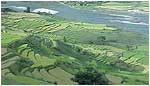 Day 10 : Stage 3 : From Trongsa the road descents gently for 7 km to the Bjee Zam bridge at 1900m (6230 ft) and then climbs 6 km through broadleaved forest to a view point from where the Trongsa Dzong still seems just a stone throw away. The road continues climbing for another 10km along cliffs and through broadleaved forests and agricultural settlements. At Tshangkha it passes the headquarters of the Jigme Singye Wangchuk National Park. After reaching Tashiling, a few km further, most of the climbing is done. In the last 20km you will only climb some 150m (500 ft), but there are some ups and downs. As you near Chendebji, hemlock replaces broadleaved species on some of the ridges and in the valley. You pass Chendebji chorten and a few km further reach the campsite near the Chendebji village (2430m, 7970 ft). 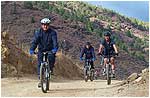 Day 11 : Stage 4 : The road climbs through mixed conifer forest past Nikachu bridge at Chazam and Rukubji to the small settlement of Longte. By this time much of the trees have been replaced by pastures and agricultural fields. Through these pastures dominated by dwarf bamboo you reach Pelela (3430m, 11250 ft). After a 3 km descent through fir, birch and rhododendron forest you reach a junction where you turn left up to Lawa La (3300m, 10830 ft) and then descent 8 km into the Phobjikha valley passing Gangtey Gonpa along the way. Phobjikha valley (2930m, 9610 ft) is famous because Bhutanís largest group of wintering black-necked cranes are found here. Unfortunately, you are too early: come back in one month. Day 11 : Stage 4 : The road climbs through mixed conifer forest past Nikachu bridge at Chazam and Rukubji to the small settlement of Longte. By this time much of the trees have been replaced by pastures and agricultural fields. Through these pastures dominated by dwarf bamboo you reach Pelela (3430m, 11250 ft). After a 3 km descent through fir, birch and rhododendron forest you reach a junction where you turn left up to Lawa La (3300m, 10830 ft) and then descent 8 km into the Phobjikha valley passing Gangtey Gonpa along the way. Phobjikha valley (2930m, 9610 ft) is famous because Bhutanís largest group of wintering black-necked cranes are found here. Unfortunately, you are too early: come back in one month. 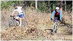 Day 12 : Stage 5 :From Phobjikha valley you work your way back up to Lawa La and the main road and from there continue the long descent to Wangdue Phodrang. After passing the village of Nobding, 12 km down, there is a single restaurant a further 12 km down and then a few shosp at Teki Zampa another 15 km further. Just past here a new Japanese bridge spans the Dang Chhu. At Chuzomsa, there is a side road to an abandoned slate mine. After a long almost flat stretch you reach Wangdue Phodrang. The town is supposed to be relocated to a site closer to the river. Drop down to the river and find your accommodation which may be 2 to 6 km from the bridge. Day 12 : Stage 5 :From Phobjikha valley you work your way back up to Lawa La and the main road and from there continue the long descent to Wangdue Phodrang. After passing the village of Nobding, 12 km down, there is a single restaurant a further 12 km down and then a few shosp at Teki Zampa another 15 km further. Just past here a new Japanese bridge spans the Dang Chhu. At Chuzomsa, there is a side road to an abandoned slate mine. After a long almost flat stretch you reach Wangdue Phodrang. The town is supposed to be relocated to a site closer to the river. Drop down to the river and find your accommodation which may be 2 to 6 km from the bridge.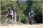 Day 13 : Stage 6 :Rest Day and Maintenance Day. Preparation for the Fury Dragon Day Day 13 : Stage 6 :Rest Day and Maintenance Day. Preparation for the Fury Dragon DayDay 14 : Stage 7 : THE FURY DRAGON DAY The race will start at Metshina, at the road junction of the Punakha and Wangdue Phodrang roads at an altitude 1410m (4625 ft). (You may need to cycle a few warm-up km to get here). The distance will be 38.3 km and the race is all uphill with an average slope of 5% (just about what an overloaded Tata Truck can handle) and a few short sections of up to 10%. The race will finish at Dochu-la pass at an altitude of 3150m (10,330 f)t. It passes Thinleygang (11 km), Lumitsawa (15km), Lampiri (28km) and a memorial chorten for traffic accident victims (32km). 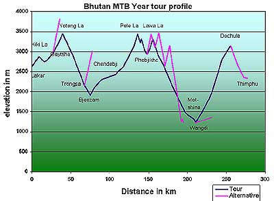 Thinleygang is the only place recognizable as a village, having a couple of shops and a BHU (Basic Health Unit). Average Bhutanese riders have done it in 3 hours 40 minutes and slow, leisure riders have taken 5-6 hours. The riders of 'The Fury Dragon Day' race will set the first official times for this race. Thinleygang is the only place recognizable as a village, having a couple of shops and a BHU (Basic Health Unit). Average Bhutanese riders have done it in 3 hours 40 minutes and slow, leisure riders have taken 5-6 hours. The riders of 'The Fury Dragon Day' race will set the first official times for this race. |
||||||